Review of Magellan Mapsend DirectRoute
Part of the Robert Lipe tech articles, robertlipe at usa dot net
This is an evolving review of Magellan's Mapsend DirectRoute. It's currently targeted toward Magellan users familiar with Mapsend and the associated receivers.
0.0 Initial version from 1200-mile Thanksgiving trip.
0.1 Additional tweaks inspired by Skramblr.
1.0 01/08/03 Add screen shots, map size info, POI list, notes on copy protection, annoyances..
1.1 01/08/03 Clarify 64MB region limit.
Why Mapsend DirectRoute?
So far in the industry, there have been two main classes of consumer GPS receivers: those meant for auto travel that will give turn-by-turn driving directions (called autorouting) and those meant for handheld use. So far in the industry, Garmin has had great success with the GPS V model which is a handheld that also autoroutes. In November of 2003, Magellan stood that model on end.
With DirectRoute and a qualifying Magellan GPS that you may have purchased even two years ago, you can now have autorouting on the hardware you already have - even though when you purchased it, no promise of autorouting was made. This is the first time that such an upgrade has been made to units already in the field and represents a tremendous value.
Upgrade: Code, Money, and Goods.
DirectRoute requires version 5.x firmware or higher and works on the modern mapping Magellans except for Meridian base (green/yellow), SporTrak Map (the SporTrak Map Pro is supported) and the 330.
Magellan does have an upgrade from previous users of Mapsend that seems to follow the Delorme model: the discounted upgrade price from the vendor is approximately the same as street price of the product ($100 USD) from dealers. So as a practical matter, the upgrade option saves you nothing.
When you open the box it contains an installation CD, a runtime CD, a firmware update CD, and a Canada map update CD plus a few small manuals and quick reference card.
This release does have copy protection in two forms. Generated maps are "bonded" to the receiver in which they will be used by entering the software-visible serial number during map generation. Additionally, the original CD must be available in the drive at runtime. Some users have reported problems with the copy protection ranging from a fear of losing/damaging the original CD to having hardware that simply won't read the disk or even laptops that don't have CD drives except while in the docking bay.
Changes to map screen
The map screen acts very differently when a street route is active. The map screen now autozooms as you approach a turn. An additional 'map info' field appears for 'Current Maneuver'. This field shows an icon of your next turn, the road you're turning onto (including exit name) and two customizable fields that default to the distance until the next turn and the distance to the destination. Oddly, the displayed map detail at the outer zoom levels is substantially less. At the .4 or .8 mile levels where Mapsend Topo used to display streets, there is now no detail. The active segment of the road is highlighted at the .2 mile level and below, and it replaced with a straight line at the further zoom levels.
Points of interest have an odd trait on the map screen. They appear only at the 100 ft level. This is a mixed blessing; in an urban area there are _so many_ this is probably the only way the roads remain visible, but it does make it difficult if you're trying to find your way to "food alley" and just get an overview of the town. They're visible out to the 500 ft level if you manually reset the detail to "high", but since that option won't "stick" and it still doesn't lend itself well to an area overview, it's not very practical.
Extremely annoyingly, DR not only disregards your preferences in Map Setup, it actively resets them on each street route Goto, making the maps for point-to-point navigation default to painful modes. Detail will be reset to Medium, track lines will be turned off, and pos-dest and depart-dest lines get unchecked. The customizable fields will be reset to total distance and distance to next turn. On a related note, a street route turns on proximity alarms for 250 feet (no matter how badly you think GPSes should be seen and not heard) and turns on the backlight on bright. I consider each of these behaviors a defect.
If you use the GPS for both foot and auto navigation, you're likely to find this a problem as you'll have to continually turn the knobs on the map screen back to sensible foot settings like turning the backtrack back on. Even if you just want a PTP goto every now and then, you'll find the absence of the pos->dest line problematic. In short, if it's going to reset all these options behind your back every time you enter a street route, it should put them back when a street route is not active.
It also has the habit of clearing the goto when it deems you're withing site of your destination. If you're navigating to a hotel, that's probably OK and maybe even desireable. Hikers will find having to enter every goto twice - once to get to the site and once on foot - problematic.
If you don't want your GPS to go off like a fire alarm on each turn, the only option I've found so far is to enter Setup->Beeper->Alarms/off. Since the proximity alarms will be turned back on (grrrr.) this allows them to go off but not bang the gong in the process.
A new screen
When a street routing is active the a new screen appears after the map and before the compass screen. It displays an overview of the trip, enumerating the turns and distances between them. This screen is not customizable.
Goto: a whole new world.
For any goto, there are now options of street routes, giving you driving directions, or point-to-point. The type cannot be changed once set. The PTP route is the same as before DirectRoute - a straight line route. The user interface for GOTO's is a hodegepodge: a mixture of pick lists, drop down boxes, and a left-right dialogue with no recollection of your previous choices and no fast way through them results in a lot of required attention to enter a destination. An extensive list of POI categories is added which makes finding food, lodging, and services quite convenient.
The Maps
The Navtech-based maps are very impressive. Most city and county parks are listed and will show on the maps as greyscale at appropriate zoom levels; Topo listed only state parks and wasn't complete at even those. While they aren't perfect (and I'm not expecting them to be) they are the most up to date in my sample area of any I've seen yet, including Streets and Trips 2004 and Delorme 2003. A road in a subdivision that was built about 18 months ago was listed and the new TN state highway terminates in the correct place and the (wierd) exit information is correct. Even Streets and Trips doesn't get this right. POI's show only when zoomed down to about the 100 foot level; even at the 250 foot zoom they disappear.
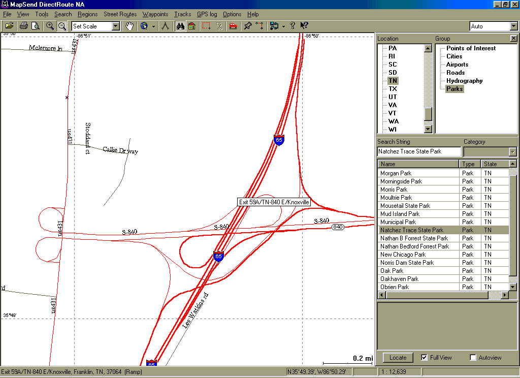
Interstates are a marked contrast to prior Mapsend iterations. Each direction in an interstate shows as a separate road on the map, which makes sense once you realize the program does utilize one-way direction and controlled access points to route. Access point information like cloverleafs have amazing detail. Several non-standard ramp configurations that I used routed flawlessly and it even had knowledge of "two stage" exits.
This is an example of a wierd interchange that is notable becuase
A) it doesn't appear on the other map programs at all and B) DirectRoute gets
the minute details right. Though it's hard to see at this zoom level,
in both northbound and southbound directions on I-65 there is a spur
that's several hundred feet long that take you to the "real" exits that
take you to 840 east or west.

Unlike competing products, there is no "region lock" silliness. You get full coverage for the area promised, you don't have to buy additional chunks of the country as you wander around. There are notes in the package that autorouting may not be available in Alaska, Mexico, and parts of Canada.
Region Preparation
On the PC, you mark the area you want to upload to your unit (called a "region") and follow the menus for a serial or SD upload. This process is substantially slower than in Mapsend Topo, presumably because of the additional road information for similar areas. You are prompted for the software-visible serial number before preparation, which is a lengthy process.
How lengthy is it? Well, Mapsend appears to not know. A progress meter is displayed with an estimated remaining time. I started a region prep on my laptop with 192MB of physical memory before dinner. After about 3 minutes, the time dropped from 45 to 18 remaining minutes. When I got up for desert, there were 19 minutes remaining. When were done with dishes, it showed 21 minutes remaining. The bar was continuing to advance so I just let it continue. About 30 minutes later, it was done. So the time estimate was pretty fictitious in my case.
Experienced Mapsend users or those that travel over a large area will find the single region limit a problem. You can only mark one rectangular area in a DirectRoute map, unlike earlier versions where you could combine four rectangular regions into a single map. Meridian users can change between maps with card utilities, but unless you have enough memory to hold the area you need or happen to need only geography that can be expressed well as a rectangle, this might be a problem. Given how many people considered the 4 rectangular region limit to be constraining, it's odd that Magellan chose to make it even more so. While Magellan has published a tech article on working with multiple regionsit isn't really working with multiple regions at all; it's reaching behind Mapsend's back to get multiple regions to the SD card. SporTrak users remain hosed.
The additional POI and street detail does come with a size price. The maps are definitely larger than those of Mapsend Topo for the same area. While I'm sure it varies by area density (I'll bet NYC grew more per square mile than Topeka).
An area that's 110 miles high and 150 miles wide that took 5,356 KB in Topo takes 9,209 KB in DirectRoute. That region includes the middle half of TN, the southern edge of KY, and the northern part of AL through the south side of Huntsville. It's described in the Magellan FAQ as the "SporTrak Map" map. The map originally drawn for the 330 goes from 7,675 KB to 12,677 KB.
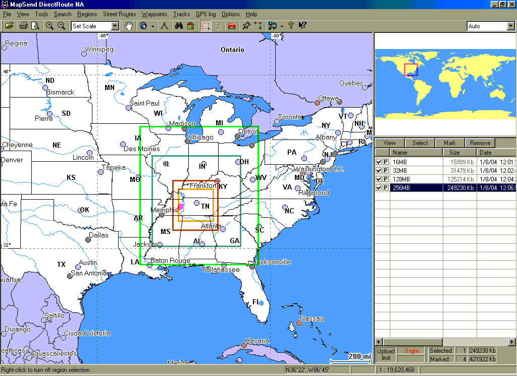
See my Magellan FAQ for additional examples, but here is an example showing DirectRoute regions of common SD card sizes of 16, 32, 128, and 256 MB. These regions are for illustration only to give you some idea of possible coverage on memory cards of popular sizes. DirectRoute limits you to 64MB regions so you can't actually produce and upload single regions of the sizes listed and therefore can't create street routes between them.

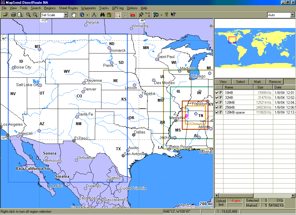
And here is an example that shows a more sparse portion of the country taking only 128MB. This really highlights that roads and POIs take map space, not square miles.

Navigating
The turn-by-turns are quite competent. They do the Right Thing with one-way roads, limited access roads, and so on. Unlike Garmin's V you can't select shortest vs. fastest - best time is always the chosen option. The system doesn't automatically recalculate a route once you deviate; you must press GOTO twice.
Route calculations take between 8 and 30 seconds. A bar graph showing progress is displayed, but I've never seen it go to completion and oddly, I've seen the bar "cycle" twice so I'm not really sure what you can expect to gain from the graphs since I've seen it be done at 20% and I've seen it to go 80% and then start over and cycle to 80% again. It's possible that the completion meter isn't a completion meter, but rather a one second spinner (thus being the wrong widget for the task at hand) but that still doesn't explain the 80% completion sometimes before restarting. In short, the completion meter tells you little more than the unit hasn't locked up.
If you navigate to a user waypoint that doesn't terminate in a road, the system doesn't cope well. The street route will think it's done when the road ends and terminate navigation, forcing you to enter another goto (and remember how cumbersome this is) to actually get to the destination. Geocachers, in particular, are likely to find this problematic.
If you enter a goto before you have a satellite lock the unit gets quite confused. The common case for this involves getting in the car while the unit is getting a cold lock (2-3 minutes) and just entering a driving direction route while it thinks it is at the position it was last used.
Conclusion
The new maps are great and if you're using it for auto navigation for tourist or business-like travelling, you're likely to be very pleased. The POI database is very complete and the driving directions will get you there. Most of the haggles I list above are visible to me as a geocacher which involves a somewhat unique mix of auto and foot navigation. The value proposition in upgrading an existing unit to include auto-routing is amazing.
My single biggest disappointment that this product doesn't include the POI's, minor water boundaries, and contour lines from Topo. While I hope that Magellan can correct most of my other haggles, I suspect this one is going to remain. A close second would be the requirement of a single, rectangular region - even with a large SD card, this makes it hard to manage a large area efficiently.
Having navigated a couple thousand miles with DirectRoute and over a hundred geocaches, I will add that my frustration with the unit hijacking my settings, the double gotos, and the backlight problems are not subsiding with time.